Waianae, Hawaii
Template:Short description Template:Distinguish Template:Use mdy dates Template:Infobox settlement
WaiTemplate:Okinaanae (Template:IPA) is a census-designated place (CDP) in the City and County of Honolulu, Hawaii, United States. As of the 2020 census, the CDP population was 13,614.
Its name means "waters of the mullet". Its etymology is shared with the far northern Wellington suburb of Waikanae, located in New Zealand.
Geography
[edit]WaiTemplate:Okinaanae is located at Template:Coord (21.447714, -158.179213).<ref name="GR1">Template:Cite web</ref>
According to the United States Census Bureau, the CDP has a total area of Template:Convert, of which Template:Convert is land and Template:Convert, or 23.92%, is water.<ref>Template:Cite web</ref>
Demographics
[edit]Template:US Census population As of the census<ref name="GR2">Template:Cite webAs of 2022, there are 13,749 people.</ref> In 2000, there were 2,595 households and 2,221 families residing in the CDP. The population density was Template:Convert. There were 2,925 housing units at an average density of Template:Convert. The racial makeup of the CDP was 9.35% White, 0.81% African American, 0.26% Native American, 19.44% Asian, 27.26% Pacific Islander, 0.97% from other races, and 41.92% from two or more races. Hispanic or Latino of any race were 14.00% of the population.
There were 2,595 households, out of which 43.9% had children under the age of 18 living with them, 58.0% were married couples living together, 19.6% had a female householder with no husband present, and 14.4% were non-families. 10.9% of all households were made up of individuals, and 4.1% had someone living alone who was 65 years of age or older. The average household size was 4.04 and the average family size was 4.30.
In the CDP the population was spread out, with 34.8% under the age of 18, 10.4% from 18 to 24, 26.8% from 25 to 44, 19.8% from 45 to 64, and 8.2% who were 65 years of age or older. The median age was 29 years. For every 100 females there were 98.9 males. For every 100 females age 18 and over, there were 94.5 males.
The median income for a household in the CDP was $46,717, and the median income for a family was $48,145. Males had a median income of $32,328 versus $22,451 for females. The per capita income for the CDP was $13,348. About 17.2% of families and 19.8% of the population were below the poverty line, including 28.6% of those under age 18 and 7.9% of those age 65 or over.
| Race NH = Non-Hispanic | % 2020<ref>Template:Cite web</ref> | % 2010<ref>Template:Cite web</ref> | % 2000<ref>Template:Cite book</ref> | Pop. 2020 | Pop. 2010 | Pop. 2000 |
|---|---|---|---|---|---|---|
| White Alone (NH) | 6.4% | 6.9% | 8% | 867 | 912 | 844 |
| Black Alone (NH) | 0.9% | 0.7% | 0.7% | 123 | 97 | 69 |
| Native American Alone (NH) | 0.1% | 0.1% | 0.2% | 14 | 16 | 21 |
| Asian Alone (NH) | 12.2% | 13.5% | 18.1% | 1666 | 1783 | 1905 |
| Pacific Islander Alone (NH) | 30.7% | 28.2% | 25.4% | 4183 | 3719 | 2672 |
| Other Race Alone (NH) | 0.2% | 0% | 0.1% | 30 | 5 | 11 |
| Multiracial (NH) | 33.4% | 34.5% | 33.4% | 4552 | 4546 | 3513 |
| Hispanic (Any race) | 16% | 15.9% | 14% | 2179 | 2099 | 1471 |
Climate
[edit]Waiʻanae has a tropical savanna climate (Köppen: Aw).
Education
[edit]The Hawaii Department of Education operates the public schools.<ref name=WaianaeMap>Template:Cite web
2000 Map: Template:Cite web - 1 and 2</ref>
District schools inside the CDP include Leihoku Elementary School, WaiTemplate:Okinaanae Elementary School, and WaiTemplate:Okinaanae Intermediate School.
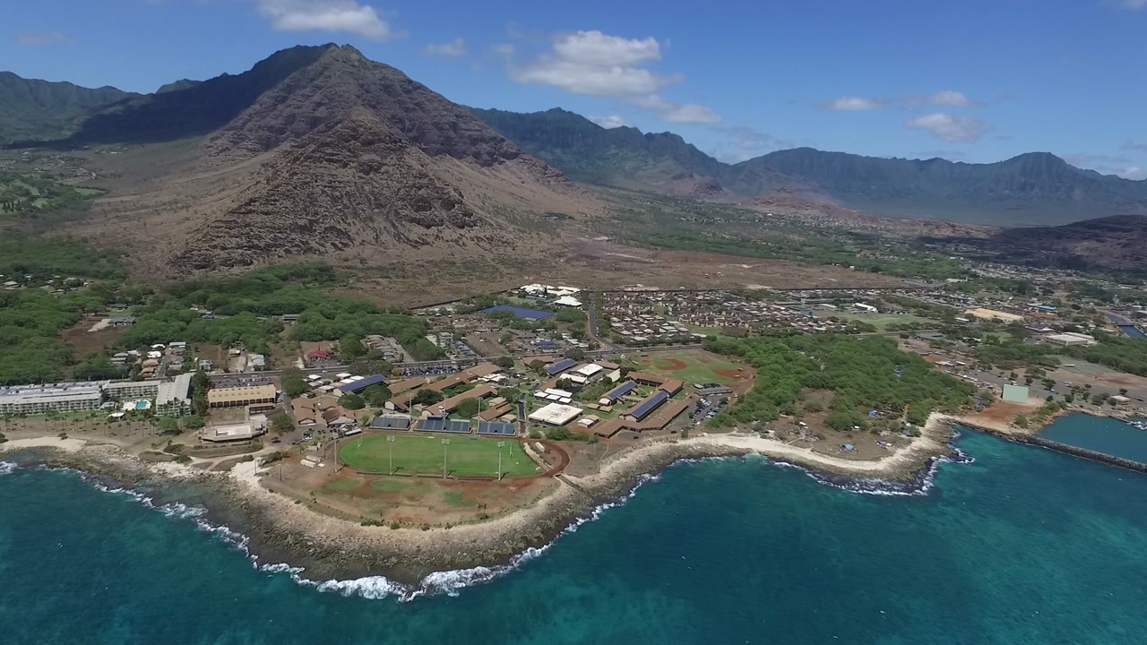
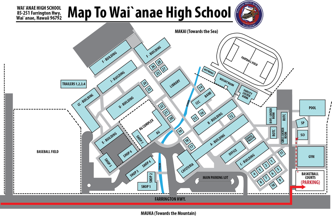
Waianae High School, which has a Waianae postal address,<ref>Template:Cite web</ref> is physically located in two CDPs:<ref>See the physical plant and school map (official website) which is apparent in a mapping program (see Hawaii GIS maps).</ref> mostly in Makaha,<ref>Template:Cite web
2000 Map: Template:Cite web</ref> and partially in Waianae.<ref name=WaianaeMap/>
The district's Kamaile Academy is outside of the CDP. A PreK-12 charter school, Ka Waihona O Ka NaTemplate:Okinaauao - New Century Pcs, is in the CDP.<ref>"Waianae CDP, HawaiiTemplate:Dead link." U.S. Census Bureau. Retrieved on May 21, 2009.</ref>
Additionally Maili Elementary School has a Waianae address but is in the Maili CDP.<ref name=MailiCDPmap>Template:Cite web
2000 Map: Template:Cite web - Compare the maps to school addresses.</ref><ref>Template:Cite web</ref>
Leeward Community College operates Wai‘anae Moku in Maili CDP; it has a Waianae postal address.<ref name=MailiCDPmap/><ref>Template:Cite web</ref>
Homeless camp
[edit]Hawaii's largest homeless camp, called Pu'uhonua o Wai'anae, is located here. It covers an area of about 20 acres adjacent to the boat harbor.<ref>Hawaii's largest homeless camp: rock bottom or a model refuge? The Guardian, 22 June 2017, retrieved 24 December 2017.</ref> Hawaii Governor David Ige met with Twinkle Borge, the leader of Pu'uhonua o Wai'anae, in March 2018, committing not to sweep the camp and displace its residents, but its future remains uncertain.<ref>Template:Cite news</ref>
Notable people
[edit]- Israel Kamakawiwoʻole, world renowned musician.
- Max Holloway, former undisputed UFC featherweight champion and current UFC Featherweight BMF Champion.
- DeForest Buckner, NFL player for the Indianapolis Colts.
- Karl Zinsman Jr., singer-songwriter