Mount Shasta, California
Template:Short description Template:About Template:Use mdy dates Template:Infobox settlement
Mount Shasta (also known as Mount Shasta City) is a city in Siskiyou County, California, United States, at about Template:Convert above sea level on the flanks of Mount Shasta, a prominent northern California landmark. The city is less than Template:Convert southwest of the summit of its namesake volcano. Its population is 3,223 as of the 2020 census, down from 3,394 from the 2010 census.
History
[edit]The site of the present-day city of Mount Shasta was within the range of the Okwanuchu tribe of Native Americans.
During the 1820s, early Euro-American trappers and hunters first passed through the area, following the path of the Siskiyou Trail. The Siskiyou Trail was based on a network of ancient Native American footpaths connecting California and the Pacific Northwest. The discovery of gold at nearby Yreka, California in 1851 dramatically increased traffic along the Siskiyou Trail and through the site of present-day Mount Shasta. Pioneer Ross McCloud built one of the first lumber mills in the area, near the site of the present Sisson Museum. The completion of a stagecoach road between Yreka and Upper Soda Springs in the late 1850s led to the building of Sisson's Hotel, as a stop for weary travelers, and as a staging ground for adventuresome tourists intending to climb Mount Shasta.Template:Citation needed
The area where the town grew was known first as Strawberry Valley, and then as Berryvale.<ref>Template:Cite book</ref> The post office opened in 1870 as Berryvale.<ref name="Orlove">Template:Cite book</ref> After 1886 it was known as Sisson after a local businessman, Justin Hinckley Sisson who ran a stagecoach inn and tavern, Strawberry Valley Station, as well as donated the land for the town site and the Central Pacific Railroad station in 1886.<ref name="Orlove" /> Street names honor members of Sisson's family.<ref name="Orlove" />
The 1887 completion of the Central Pacific Railroad, built along the line of the Siskiyou Trail, brought a dramatic increase in tourism, lumbering, and population into Mount Shasta. This early development continued to focus on tourism and lumbering. The early 1900s saw the influx of a large number of Italian immigrants to Mount Shasta and neighboring towns, most of whom were employed in the timber industry.Template:Citation needed
The city incorporated on May 31, 1905.<ref>Template:Cite book</ref> The name of the city was finalized "City of Mount Shasta" on November 10, 1925,<ref name="Miesse">Template:Cite book</ref><ref name="Hellmann2006">Template:Cite book</ref> after a popular vote in 1922.
Geography
[edit]
Mount Shasta is located at 41°18'52" North, 122°18'41" West (41.314542, -122.311510),<ref name="GR1">Template:Cite web</ref> along Interstate 5 south of Weed and north of Dunsmuir, California.
According to the United States Census Bureau, the city has a total area of Template:Convert, of which Template:Convert is land and only 0.10% of it is covered by water.
The area hydrology consists of an unnamed stream in the south part of town which joins Big Springs Creek, which then flows south as Cold Creek to join the headwaters of the South Fork of the Sacramento River.<ref>U.S. Geological Survey, Weed 15 Minute Quadrangle, U.S. Government Printing Office, Washington DC (1954)</ref> The typical depth to groundwater is quite shallow in the predominant alluvium.<ref>Phase I Environmental Site Assessment,301 West Lake Street, Mount Shasta, California, Earth Metrics Incorporated, San Mateo, California, Report Number 10363, December 18, 1989</ref>
The settlement is on the distal gently sloping southwest flanks of Mount Shasta, with the chief surficial soils being Quaternary alluvium. This alluvium is adjacent to and probably underlain by volcanic clastic rock deposited by Mount Shasta in the course of its development. Groundwater elevation is approximately at the elevation of the underlying native black peat soil. Where it occurs this peat, of approximately two feet thickness, is underlain by stream deposit sands and gravels.
Climate
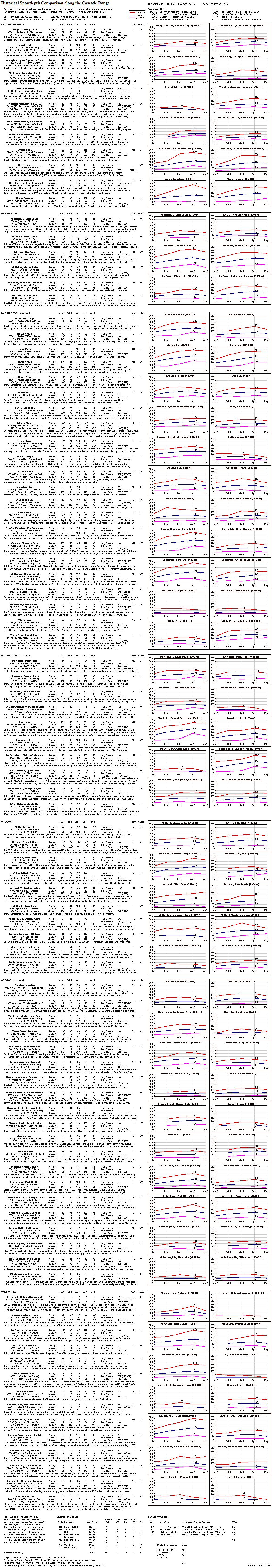
[edit]Mount Shasta to the east forces moisture out of the air as it rises and cools, and the dip in the Klamath Mountains allows more moisture to reach inland, so the city receives more precipitation than the semiarid region to the north. This means that in the winter, the city gets nearly Template:Convert of snowfall despite its low Template:Convert elevation.<ref>Information about Cascade Snowdepth Measurement Sites, Skiing the Cascade Volcanoes, April 2005, accessed April 23, 2013</ref> Other towns in the region get much less snow,<ref>Cascade Snow Depth Comparison, Skiing the Cascade Volcanoes, April 2005, accessed April 23, 2013</ref> for example Yreka averages only Template:Convert, and much cooler Klamath Falls only Template:Convert. The Köppen climate classification is Csb, or warm-summer Mediterranean climate. It can be very warm and cold according to the Californian summer anex. The USDA hardiness zone is 7b.
The record high temperature was Template:Convert on July 29, 2022, and the record low temperature was Template:Convert on December 22, 1990.<ref name = "WB">Mount Shasta, California Monthly - Weather Averages Summary, Weatherbase, accessed April 23, 2013</ref> The wettest “rain year” was from July 1997 to June 1998 with Template:Convert and the driest from July 1976 to June 1977 with Template:Convert. The most rainfall in one month was Template:Convert in January 1995, including Template:Convert on January 9. The most snowfall in one year was Template:Convert in 1952, including Template:Convert in January 1952.<ref>Mount Shasta, California (045983) Period of Record Monthly Climate Summary, Western Regional Climate Center, 2010, accessed April 23, 2013</ref> The most snow on the ground was Template:Convert on December 31, 1992.
Demographics
[edit]2010
[edit]The 2010 United States Census<ref>Template:Cite web</ref> reported that Mount Shasta had a population of 3,394. The population density was Template:Convert. The racial makeup of Mount Shasta was 3,041 (89.6%) White, 61 (1.8%) African American, 19 (0.6%) Native American, 56 (1.6%) Asian, 2 (0.1%) Pacific Islander, 51 (1.5%) from other races, and 164 (4.8%) from two or more races. Hispanic or Latino of any race were 277 persons (8.2%).
The Census reported that 3,358 people (98.9% of the population) lived in households, 6 (0.2%) lived in non-institutionalized group quarters, and 30 (0.9%) were institutionalized.
There were 1,664 households, out of which 401 (24.1%) had children under the age of 18 living in them, 537 (32.3%) were married couples, 190 (11.4%) had a female householder with no husband present, 84 (5.0%) had a male householder with no wife present. There were 113 (6.8%) unmarried couples, and only 9 (0.5%) same-sex couples. 719 households (43.2%) were made up of individuals, and 285 (17.1%) had someone living alone who was 65 years of age or older. The average household size was 2.02. There were 811 families (48.7% of all households); the average family size was 2.79.
The population was spread out, with 692 people (20.4%) under the age of 18, 242 people (7.1%) aged 18 to 24, 732 people (21.6%) aged 25 to 44, 1,109 people (32.7%) aged 45 to 64, and 619 people (18.2%) who were 65 years of age or older. The median age was 45.7 years. For every 100 females, there were 84.7 males. For every 100 females age 18 and over, there were 80.6 males.
There were 1,895 housing units at an average density of Template:Convert, of which 781 (46.9%) were owner-occupied, and 883 (53.1%) were occupied by renters. The homeowner vacancy rate was 2.5%; the rental vacancy rate was 5.8%. 1,699 people (50.1% of the population) lived in owner-occupied housing units and 1,659 people (48.9%) lived in rental housing units.
2000
[edit]As of the census of 2000, there were 3,621 people, 1,669 households, and 926 families residing in the city. The population density was Template:Convert. There were 1,798 housing units at an average density of Template:Convert. The racial makeup of the city was 91.77% White, 1.52% Black or African American, 0.44% Native American, 1.63% Asian, 0.14% Pacific Islander, 2.13% from other races, and 2.38% from two or more races. 5.83% of the population were Hispanic or Latino of any race.
There were 1,669 households, out of which 27.9% had children under the age of 18 living with them, 38.1% were married couples living together, 12.3% had a female householder with no husband present, and 44.5% were non-families. 38.0% of all households were made up of individuals, and 16.0% had someone living alone who was 65 years of age or older. The average household size was 2.14 and the average family size was 2.83.
In the city, the population was spread out, with 24.0% under the age of 18, 7.7% from 18 to 24, 24.5% from 25 to 44, 26.4% from 45 to 64, and 17.5% who were 65 years of age or older. The median age was 42 years. For every 100 females, there were 87.9 males. For every 100 females age 18 and over, there were 84.5 males.
The median income for a household in the city was $26,500, and the median income for a family was $37,313. Males had a median income of $37,697 versus $18,708 for females. The per capita income for the city was $20,629. 19.4% of the population and 14.9% of families were below the poverty line. Out of the total population, 31.5% of those under the age of 18 and 11.2% of those 65 and older were living below the poverty line.
Economy
[edit]
The city of Mount Shasta is located in the Shasta Cascade area of Northern California.<ref name = coc>Welcome to Mount Shasta, Mount Shasta Chamber of Commerce, accessed April 23, 2013</ref> Visitors use the city as a base for trout fishing in the nearby Sacramento, McCloud and Klamath rivers,<ref name = 100best>Template:Cite book</ref><ref name = flyfishing>Template:Cite book</ref> for climbing at Mount Shasta, Castle Crags or the Trinity Alps, or to view scenery.<ref name = coc/><ref name = gorp>Outdoor recreational activities in area accessed February 24, 2008</ref> Both alpine and cross-country skiing<ref name = ski>Mount Shasta Template:Convert, Skiing the Cascade Volcanoes, accessed April 23, 2013</ref> runs are available nearby as well as biking or hiking to waterfalls, streams and lakes in the area, including nearby Mossbrae Falls, Lake Siskiyou, Castle Lake and Shasta Lake.<ref name = coc/><ref name = gorp/>
Government
[edit]
The city council of Mount Shasta is composed of seven officials: five city council members, a City Treasurer and a City Clerk who are elected at large and serve a four-year term.<ref name = "elected">Elected Officials, City of Mount Shasta, 2014</ref> The Mayor and Mayor Pro Tempore are elected each year from the five council members and serve a one-year term. Kathy Morter is currently serving as Mayor of Mount Shasta until November 2018, with Timothy Stearns serving as Mayor Pro Tem.<ref name = "elected" />
In the state legislature Mount Shasta is in Template:Representative,<ref>Template:Cite web</ref> and Template:Representative.<ref>Template:Cite web</ref>
Federally, Mount Shasta is in Template:Representative.<ref>Template:Cite GovTrack</ref>
Media
[edit]- KHWA 99.3/102.3 FM Jefferson Public Radio, Mount Shasta
- KZRO-FM 100.1 Mount Shasta
- KKLC 107.9 K-LOVE, Fall River Mills
- KNSQ-FM 88.1 Jefferson Public Radio, Mount Shasta
- KLDD-FM 91.9 Jefferson Public Radio, Mount Shasta
- KMJC-AM 620 Jefferson Public Radio, Mount Shasta
- Mount Shasta Herald
- Vyve Broadband
- MCTV 15 Mountain Community Television/Siskiyou Media Council
Notable people
[edit]- Terry Huntingdon – Miss California USA 1959, Miss USA 1959
- Ann Little – silent-film actress
- Anita Loos – writer and author of the screenplay Gentlemen Prefer Blondes was born in Sisson (now Mount Shasta) in 1888
- Tony Olmos – film director and screenwriter
- Jason Sehorn – former NFL cornerback, graduated Mount Shasta High School in 1989
- D. J. Wilson – basketball player, first-round selection in 2017 NBA draft; born in Mount Shasta
See also
[edit]References
[edit]External links
[edit]- Template:Official website
- Template:Osmway
- Museum of the Siskiyou Trail
- Images of Mount Shasta from the Eastman’s Originals Collection, Special Collections Dept., University of California, Davis.
Template:Shasta Cascade Template:Siskiyou County, California Template:Authority control